Geolocate

Birchden topographic map

Click on the map to display elevation.

About this map

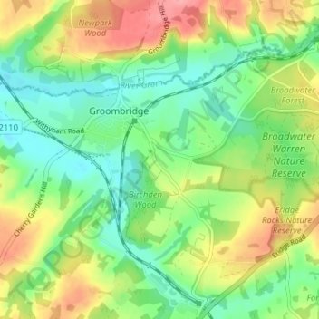
Name: Birchden topographic map, elevation, terrain.

Location: Birchden, Withyham, Groombridge, Wealden, East Sussex, England, TN3 9NJ, United Kingdom (51.08735 0.17316 51.12735 0.21316)

Average elevation: 77 m

Minimum elevation: 39 m

Maximum elevation: 135 m

Other topographic maps

Click on a map to view its topography, its elevation and its terrain.

Gear up for your next adventure:

💡Compact LED Flashlight - Powerful and portable flashlight for outdoor use
🧦Merino Wool Socks - Moisture-wicking comfort for long-distance hiking
👟Sport Hiking Sandals - Breathable footwear for water crossings and camp rest
🧊Portable Cooler - Keep food and drinks cold during outdoor adventures
🧣Merino Neck Gaiter - Protects against wind, sun, and cold at high altitudes

As an Amazon Associate, this site earns from qualifying purchases at no extra cost to you.