
Make a donation
Gear up for your next adventure:
As an Amazon Associate, this site earns from qualifying purchases at no extra cost to you.
Fulton Township topographic map
Click on the map to display elevation.
Make a donation
Gear up for your next adventure:
As an Amazon Associate, this site earns from qualifying purchases at no extra cost to you.
About this map
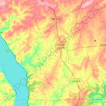
Name: Fulton Township topographic map, elevation, terrain.
Average elevation: 113 m
Minimum elevation: 25 m
Maximum elevation: 195 m
Make a donation
Gear up for your next adventure:
As an Amazon Associate, this site earns from qualifying purchases at no extra cost to you.
Other topographic maps
Click on a map to view its topography, its elevation and its terrain.
Ronks
United States > Pennsylvania > Lancaster County > East Lampeter Township
Average elevation: 115 m
East Earl
United States > Pennsylvania > Lancaster County > East Earl Township
Average elevation: 165 m
Schoeneck
United States > Pennsylvania > Lancaster County > West Cocalico Township
Average elevation: 157 m
Make a donation
Gear up for your next adventure:
As an Amazon Associate, this site earns from qualifying purchases at no extra cost to you.
Conestoga
United States > Pennsylvania > Lancaster County > Conestoga Township
Average elevation: 118 m
Make a donation
Gear up for your next adventure:
As an Amazon Associate, this site earns from qualifying purchases at no extra cost to you.
Eagle Rock
United States > Pennsylvania > Lancaster County > Elizabeth Township
Average elevation: 193 m
Chickies Rock
United States > Pennsylvania > Lancaster County > West Hempfield Township
Average elevation: 106 m
Make a donation
Gear up for your next adventure:
As an Amazon Associate, this site earns from qualifying purchases at no extra cost to you.
Salunga
United States > Pennsylvania > Lancaster County > East Hempfield Township
Average elevation: 118 m
Fertility
United States > Pennsylvania > Lancaster County > East Lampeter Township
Average elevation: 110 m
Glen Moore
United States > Pennsylvania > Lancaster County > Manheim Township
Average elevation: 109 m
Indian Rocks
United States > Pennsylvania > Lancaster County > East Cocalico Township
Average elevation: 161 m
Make a donation
Gear up for your next adventure:
As an Amazon Associate, this site earns from qualifying purchases at no extra cost to you.
Blainsport
United States > Pennsylvania > Lancaster County > West Cocalico Township
Average elevation: 174 m
Make a donation
Gear up for your next adventure:
As an Amazon Associate, this site earns from qualifying purchases at no extra cost to you.
Make a donation
Gear up for your next adventure:
As an Amazon Associate, this site earns from qualifying purchases at no extra cost to you.