Geolocate

Bachevo topographic map

Click on the map to display elevation.

About this map

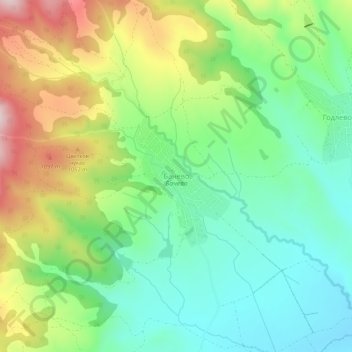
Name: Bachevo topographic map, elevation, terrain.

Location: Bachevo, Razlog, Blagoevgrad, 2769, Bulgaria (41.90192 23.43272 41.94192 23.47272)

Average elevation: 942 m

Minimum elevation: 810 m

Maximum elevation: 1,175 m

Other topographic maps

Click on a map to view its topography, its elevation and its terrain.

Рупите

Bulgaria > Blagoevgrad

Average elevation: 117 m

Тевно езеро

Bulgaria > Blagoevgrad

Average elevation: 2,429 m

Frog lake

Bulgaria > Blagoevgrad

Average elevation: 2,410 m

Gear up for your next adventure:

🧼Travel Hand Sanitizer - Keep hands clean when water is scarce
👖Convertible Hiking Pants - Zip-off legs to adapt to changing weather conditions
👟Sport Hiking Sandals - Breathable footwear for water crossings and camp rest
🧥Insulated Jacket - Keep warm in cold outdoor conditions
💧Reusable Water Bottle - Durable water bottles for hydration on trails

As an Amazon Associate, this site earns from qualifying purchases at no extra cost to you.