
Make a donation
Gear up for your next adventure:
As an Amazon Associate, this site earns from qualifying purchases at no extra cost to you.
Odeweg topographic map
Click on the map to display elevation.
Make a donation
Gear up for your next adventure:
As an Amazon Associate, this site earns from qualifying purchases at no extra cost to you.
About this map
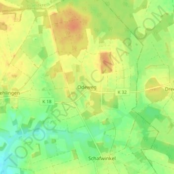
Name: Odeweg topographic map, elevation, terrain.
Average elevation: 54 m
Minimum elevation: 36 m
Maximum elevation: 69 m
Make a donation
Gear up for your next adventure:
As an Amazon Associate, this site earns from qualifying purchases at no extra cost to you.
Other topographic maps
Click on a map to view its topography, its elevation and its terrain.
Neddenaverbergen
Deutschland > Niedersachsen > Landkreis Verden > Kirchlinteln
In der Endphase des Zweiten Weltkrieges fand in Neddenaverbergen ein Raketen-Sonderschießen in Richtung eines Zielgebiets nahe Sylt statt, das die Zielgenauigkeit der V2 erhöhen sollte.
Average elevation: 36 m
Holtum (Geest)
Deutschland > Niedersachsen > Landkreis Verden > Kirchlinteln
Geprägt ist die Landschaft von den welligen Höhenrücken der Achim-Verdener Geest, die ihrerseits den Südwestrand der Stader Geest bildet. Im Wald nahe Holtum ist am Funkturm die höchste Erhebung im Landkreis Verden zu finden. Holtum liegt auf einer Wasserscheide. Im Norden entwässert das bis an den…
Average elevation: 50 m
Make a donation
Gear up for your next adventure:
As an Amazon Associate, this site earns from qualifying purchases at no extra cost to you.