Geolocate

Coquille topographic map

Click on the map to display elevation.

About this map

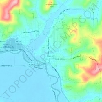
Name: Coquille topographic map, elevation, terrain.

Location: Coquille, Coos County, Oregon, United States (43.16283 -124.21542 43.19499 -124.16128)

Average elevation: 40 m

Minimum elevation: -5 m

Maximum elevation: 186 m

Other topographic maps

Click on a map to view its topography, its elevation and its terrain.

Englewood

United States > Oregon > Coos County > Coos Bay

Average elevation: 41 m

Sitkum

United States > Oregon > Coos County

Average elevation: 336 m

Charleston

United States > Oregon > Coos County

Average elevation: 24 m

Bullards

United States > Oregon > Coos County

Average elevation: 9 m

Randolph

United States > Oregon > Coos County

Average elevation: 36 m

Lampa Mountain

United States > Oregon > Coos County

Average elevation: 109 m

Sitkum

United States > Oregon > Coos County

Average elevation: 336 m

Whiskey Run Beach

United States > Oregon > Coos County

Average elevation: 22 m

Gear up for your next adventure:

👟Trail Running Shoes - Agile footwear for fast-paced topographic exploration
🏃Hydration Running Vest - Carry water and maps close to your body for speed
🕶️Polarized Sunglasses - Reduces glare from snow and water at high elevations
🧦Crew Hiking Socks - Comfortable socks for long-distance hikes
🗺️Topographic Maps - Detailed maps to explore trails, mountains, and wilderness areas

As an Amazon Associate, this site earns from qualifying purchases at no extra cost to you.