
Sitkum topographic map
Click on the map to display elevation.
About this map
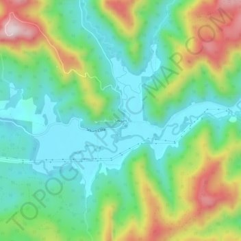
Name: Sitkum topographic map, elevation, terrain.
Location: Sitkum, Coos County, Oregon, United States (43.12817 -123.88120 43.16817 -123.84120)
Average elevation: 336 m
Minimum elevation: 166 m
Maximum elevation: 690 m
Other topographic maps
Click on a map to view its topography, its elevation and its terrain.
Coos Bay
United States > Oregon > Coos County
According to the United States Census Bureau, the city has a total area of 15.90 square miles (41.18 km2), of which, 10.60 square miles (27.45 km2) is land and 5.30 square miles (13.73 km2) is water. The city is quite hilly, with elevations ranging from between sea level to over 500 feet (150 m). Bodies of…
Average elevation: 30 m