
Make a donation
Gear up for your next adventure:
As an Amazon Associate, this site earns from qualifying purchases at no extra cost to you.
Gingen an der Fils topographic map
Click on the map to display elevation.
Make a donation
Gear up for your next adventure:
As an Amazon Associate, this site earns from qualifying purchases at no extra cost to you.
About this map
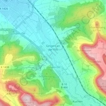
Name: Gingen an der Fils topographic map, elevation, terrain.
Average elevation: 472 m
Minimum elevation: 362 m
Maximum elevation: 723 m
Make a donation
Gear up for your next adventure:
As an Amazon Associate, this site earns from qualifying purchases at no extra cost to you.
Other topographic maps
Click on a map to view its topography, its elevation and its terrain.
Zwerenberg
Deutschland > Baden-Württemberg > Landkreis Göppingen > Lauterstein
Average elevation: 717 m
Hohenstaufen
Deutschland > Baden-Württemberg > Landkreis Göppingen > Göppingen
Average elevation: 473 m
Aichelberg
Deutschland > Baden-Württemberg > Landkreis Göppingen > Aichelberg > Aichelberg
Die Gemeinde Aichelberg liegt zwischen Stuttgart und Ulm und in Luftlinie etwa zehn Kilometer südwestlich der Kreisstadt Göppingen am Albtrauf, dem Nordwestabhang der Schwäbischen Alb, in einer Höhe von 357 bis 615 m ü. NHN. Das langgestreckte Gebiet der Gemeinde zieht sich von etwas unterhalb des…
Average elevation: 431 m
Make a donation
Gear up for your next adventure:
As an Amazon Associate, this site earns from qualifying purchases at no extra cost to you.
Hattenhofen
Deutschland > Baden-Württemberg > Landkreis Göppingen > Hattenhofen > Hattenhofen
Average elevation: 377 m
Eybach
Deutschland > Baden-Württemberg > Landkreis Göppingen > Geislingen an der Steige > Eybach
Average elevation: 619 m
Unterdrackenstein
Deutschland > Baden-Württemberg > Landkreis Göppingen > Drackenstein
Average elevation: 734 m
Make a donation
Gear up for your next adventure:
As an Amazon Associate, this site earns from qualifying purchases at no extra cost to you.
Türkheim
Deutschland > Baden-Württemberg > Landkreis Göppingen > Geislingen an der Steige
Average elevation: 645 m
Make a donation
Gear up for your next adventure:
As an Amazon Associate, this site earns from qualifying purchases at no extra cost to you.
Schopflenberg
Deutschland > Baden-Württemberg > Landkreis Göppingen > Göppingen
Average elevation: 370 m
Make a donation
Gear up for your next adventure:
As an Amazon Associate, this site earns from qualifying purchases at no extra cost to you.
Bünzwangen
Deutschland > Baden-Württemberg > Landkreis Göppingen > Ebersbach an der Fils
Average elevation: 341 m
Hofstett am Steig
Deutschland > Baden-Württemberg > Landkreis Göppingen > Geislingen an der Steige > Weiler ob Helfenstein
Average elevation: 612 m
Eselhöfe
Deutschland > Baden-Württemberg > Landkreis Göppingen > Mühlhausen im Täle
Average elevation: 710 m
Make a donation
Gear up for your next adventure:
As an Amazon Associate, this site earns from qualifying purchases at no extra cost to you.
Make a donation
Gear up for your next adventure:
As an Amazon Associate, this site earns from qualifying purchases at no extra cost to you.
Krummwälden
Deutschland > Baden-Württemberg > Landkreis Göppingen > Eislingen/Fils
Average elevation: 392 m
Lützelalb
Deutschland > Baden-Württemberg > Landkreis Göppingen > Weißenstein
Average elevation: 661 m
Make a donation
Gear up for your next adventure:
As an Amazon Associate, this site earns from qualifying purchases at no extra cost to you.
Schinder
Deutschland > Baden-Württemberg > Landkreis Göppingen > Rechberghausen
Average elevation: 365 m
Weiler ob Helfenstein
Deutschland > Baden-Württemberg > Landkreis Göppingen > Geislingen an der Steige
Average elevation: 601 m
Make a donation
Gear up for your next adventure:
As an Amazon Associate, this site earns from qualifying purchases at no extra cost to you.
Eschenbäche
Deutschland > Baden-Württemberg > Landkreis Göppingen > Eislingen/Fils
Average elevation: 415 m
Hohenstaufen
Deutschland > Baden-Württemberg > Landkreis Göppingen > Göppingen
Average elevation: 473 m