
Make a donation
Gear up for your next adventure:
As an Amazon Associate, this site earns from qualifying purchases at no extra cost to you.
Aichelberg topographic map
Click on the map to display elevation.
Make a donation
Gear up for your next adventure:
As an Amazon Associate, this site earns from qualifying purchases at no extra cost to you.
Aichelberg
Die Gemeinde Aichelberg liegt zwischen Stuttgart und Ulm und in Luftlinie etwa zehn Kilometer südwestlich der Kreisstadt Göppingen am Albtrauf, dem Nordwestabhang der Schwäbischen Alb, in einer Höhe von 357 bis 615 m ü. NHN. Das langgestreckte Gebiet der Gemeinde zieht sich von etwas unterhalb des Boßler-Gipfels (799,9 m ü. NHN) auf einem fallenden Kamm über dessen zwei Ausläufe Turmberg (608,6 m ü. NHN) und Aichelberg (564,2 m ü. NHN) hinunter zum Dorf Aichelberg am Hangfuß und bis in die vorgelagerte Ebene.
Make a donation
Gear up for your next adventure:
As an Amazon Associate, this site earns from qualifying purchases at no extra cost to you.
About this map
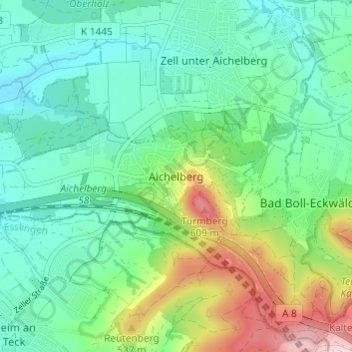
Name: Aichelberg topographic map, elevation, terrain.
Average elevation: 431 m
Minimum elevation: 353 m
Maximum elevation: 631 m
Make a donation
Gear up for your next adventure:
As an Amazon Associate, this site earns from qualifying purchases at no extra cost to you.