
Make a donation
Gear up for your next adventure:
As an Amazon Associate, this site earns from qualifying purchases at no extra cost to you.
Tudor topographic map
Click on the map to display elevation.
Make a donation
Gear up for your next adventure:
As an Amazon Associate, this site earns from qualifying purchases at no extra cost to you.
About this map
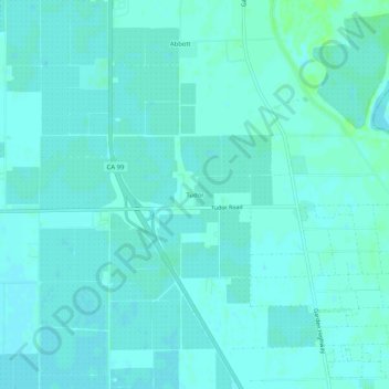
Name: Tudor topographic map, elevation, terrain.
Average elevation: 13 m
Minimum elevation: 10 m
Maximum elevation: 19 m
Make a donation
Gear up for your next adventure:
As an Amazon Associate, this site earns from qualifying purchases at no extra cost to you.
Other topographic maps
Click on a map to view its topography, its elevation and its terrain.
Yuba City
United States > California > Sutter County
On March 14, 1961, a Boeing B-52 Stratofortress carrying nuclear weapons, flying near Yuba City, encountered a pressurization problem, and had to drop to a lower altitude. Because of this, more fuel than expected was used, and the aircraft ran out of fuel. It crashed before meeting with a tanker aircraft. The…
Average elevation: 18 m
Make a donation
Gear up for your next adventure:
As an Amazon Associate, this site earns from qualifying purchases at no extra cost to you.