Geolocate

LaSalle topographic map

Click on the map to display elevation.

About this map

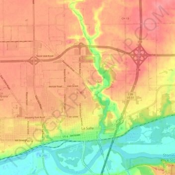
Name: LaSalle topographic map, elevation, terrain.

Location: LaSalle, LaSalle County, Illinois, 61301, United States (41.31460 -89.12062 41.39035 -89.01014)

Average elevation: 180 m

Minimum elevation: 132 m

Maximum elevation: 211 m

Other topographic maps

Click on a map to view its topography, its elevation and its terrain.

Wedron

United States > Illinois > LaSalle County

Average elevation: 179 m

Hitt

United States > Illinois > LaSalle County > Ottawa

Average elevation: 174 m

Dayton

United States > Illinois > LaSalle County

Average elevation: 179 m

Serena

United States > Illinois > LaSalle County

Average elevation: 192 m

Gear up for your next adventure:

🧴Waterproofing Spray - Restore the DWR coating on jackets and tents
🛶Canoe Life Vest - Safety vest for water sports
💧Filtered Water Bottle - Safe drinking water on the go
🎒Hiking Backpack - Lightweight and ergonomic backpacks for day hikes or multi-day treks
🛏️Sleeping Bag - Warm and compact sleeping bags for outdoor camping

As an Amazon Associate, this site earns from qualifying purchases at no extra cost to you.