Geolocate

Jensen topographic map

Click on the map to display elevation.

About this map

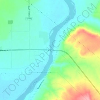
Name: Jensen topographic map, elevation, terrain.

Location: Jensen, Uintah County, Utah, 84035, United States (40.34968 -109.35485 40.38968 -109.31485)

Average elevation: 1,470 m

Minimum elevation: 1,437 m

Maximum elevation: 1,561 m

Other topographic maps

Click on a map to view its topography, its elevation and its terrain.

Green River

United States > Utah > Uintah County

Average elevation: 1,576 m

Vernal

United States > Utah > Uintah County

Average elevation: 1,625 m

Green River

United States > Utah > Uintah County

Average elevation: 1,431 m

Naples

United States > Utah > Uintah County

Average elevation: 1,595 m

Vernal

United States > Utah > Uintah County

Average elevation: 1,625 m

Green River

United States > Utah > Uintah County

Average elevation: 1,500 m

Steinaker Reservoir

United States > Utah > Uintah County

Average elevation: 1,690 m

Red Fleet Reservoir

United States > Utah > Uintah County

Average elevation: 1,733 m

Vernal

United States > Utah > Uintah County

Average elevation: 1,625 m

Fort Duchesne

United States > Utah > Uintah County

Average elevation: 1,545 m

Vernal

United States > Utah > Uintah County

Average elevation: 1,625 m

Naples

United States > Utah > Uintah County > Naples

Average elevation: 1,595 m

Gear up for your next adventure:

💧Hydration Bladder - Hands-free hydration solution for long treks
🚲MTB Frame Bag - Carry tools and maps directly on your bicycle frame
🧥Waterproof Pants - Keep dry during rainy hiking conditions
🥾Approach Shoes - Shoes designed for climbing approaches and rugged trails
🧥Ultralight Puffy Jacket - Maximum warmth that packs down to the size of an orange

As an Amazon Associate, this site earns from qualifying purchases at no extra cost to you.