
Woburn topographic map
Click on the map to display elevation.
About this map
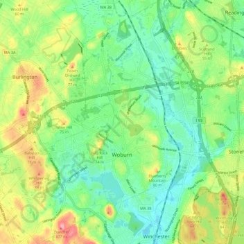
Name: Woburn topographic map, elevation, terrain.
Average elevation: 40 m
Minimum elevation: 4 m
Maximum elevation: 103 m
Other topographic maps
Click on a map to view its topography, its elevation and its terrain.
Framingham Center
United States > Massachusetts > Middlesex County > Framingham
Average elevation: 58 m
Medford Hillside
United States > Massachusetts > Middlesex County > Medford > West Medford
Average elevation: 13 m
North Chelmsford
United States > Massachusetts > Middlesex County > Chelmsford
Average elevation: 41 m
Winchester Highlands
United States > Massachusetts > Middlesex County > Winchester
Average elevation: 35 m
Windsor at Oak Grove
United States > Massachusetts > Middlesex County > Melrose
Average elevation: 31 m
Oak Hill
United States > Massachusetts > Middlesex County > Newton
This village is situated on a landform known since the mid-17th century as Oak Hill, and one of the seven principal elevations of Newton (the others being Nonantum Hill, Waban Hill, Chestnut Hill, Bald Pate Hill, Institution Hill, and Mount Ida).
Average elevation: 43 m
Hobbs Road
United States > Massachusetts > Middlesex County > Wayland > Cochituate
Average elevation: 66 m
Cambridge
United States > Massachusetts > Middlesex County > Cambridge
Cambridge obtains water from Hobbs Brook (in Lincoln and Waltham) and Stony Brook (Waltham and Weston), as well as an emergency connection to the Massachusetts Water Resources Authority. The city owns over 1,200 acres (486 ha) of land in other towns that includes these reservoirs and portions of their…
Average elevation: 31 m
Arlington Heights
United States > Massachusetts > Middlesex County > Arlington
Average elevation: 58 m
North Chelmsford
United States > Massachusetts > Middlesex County > Chelmsford
Average elevation: 41 m
Weston Station
United States > Massachusetts > Middlesex County > Weston > Weston Station
Average elevation: 55 m
East Acton
United States > Massachusetts > Middlesex County > Acton > East Acton
Average elevation: 53 m