Geolocate

Stikal topographic map

Click on the map to display elevation.

About this map

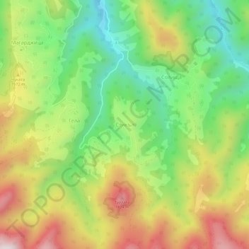
Name: Stikal topographic map, elevation, terrain.

Location: Stikal, Smolian, Smolyan, 4838, Bulgaria (41.62310 24.56369 41.66310 24.60369)

Average elevation: 1,470 m

Minimum elevation: 1,147 m

Maximum elevation: 1,888 m

Gear up for your next adventure:

🔥Camping Stove - Portable stoves to cook outdoors with ease
🧦Hiking Socks - Moisture-wicking and comfortable socks for long hikes
🚑Survival Whistle - Signal for help across long distances in mountains
🥾Mountain Trail Shoes - High-traction shoes for mountain trails
🩹Compact First Aid Kit - Pre-packed essentials for common trail injuries

As an Amazon Associate, this site earns from qualifying purchases at no extra cost to you.