Geolocate

Paril topographic map

Click on the map to display elevation.

About this map

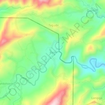
Name: Paril topographic map, elevation, terrain.

Location: Paril, Cebu City, Central Visayas, Philippines (10.45497 123.89590 10.49497 123.93590)

Average elevation: 231 m

Minimum elevation: 83 m

Maximum elevation: 462 m

Other topographic maps

Click on a map to view its topography, its elevation and its terrain.

Butuanon River

Philippines > Cebu City

Average elevation: 44 m

Fort San Pedro

Philippines > Cebu City

Average elevation: 3 m

San Roque

Philippines > Cebu City

Average elevation: 4 m

Hippodromo Park

Philippines > Cebu City

Average elevation: 13 m

Pari-an

Philippines > Cebu City

Average elevation: 8 m

TIEZA Pond

Philippines > Cebu City > Malubog

Average elevation: 471 m

Guadalupe River

Philippines > Cebu City

Average elevation: 220 m

Butuanon River

Philippines > Cebu City

Average elevation: 105 m

Kotkot River

Philippines > Cebu City

Average elevation: 316 m

SM Tower

Philippines > Cebu City

Average elevation: 3 m

Butuanon River

Philippines > Cebu City

Average elevation: 85 m

Butuanon River

Philippines > Cebu City

Average elevation: 41 m

CBP Central Park

Philippines > Cebu City

Average elevation: 19 m

Butuanon River

Philippines > Cebu City

Average elevation: 230 m

Sambag I

Philippines > Cebu City

Average elevation: 14 m

Mananga River

Philippines > Cebu City > Buot

Average elevation: 351 m

Buhisan Dam

Philippines > Cebu City > To-ong > Puti

Average elevation: 221 m

Gear up for your next adventure:

🛌Insulated Sleeping Pad - Critical thermal barrier between you and the cold ground
🧊Portable Cooler - Keep food and drinks cold during outdoor adventures
🥾Trekking Poles - Adjustable trekking poles to reduce knee stress and improve stability
🏕️Camping Hammock - Integrated protection for sleeping between trees
Camping Groundsheet - Protect your tent from moisture and dirt

As an Amazon Associate, this site earns from qualifying purchases at no extra cost to you.