Geolocate

Witham topographic map

Click on the map to display elevation.

About this map

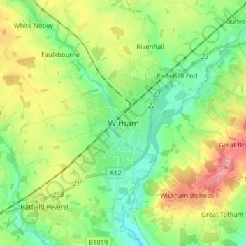
Name: Witham topographic map, elevation, terrain.

Location: Witham, Essex, East of England, England, CM8 2DZ, United Kingdom (51.76196 0.59837 51.84196 0.67837)

Average elevation: 39 m

Minimum elevation: 6 m

Maximum elevation: 93 m

Gear up for your next adventure:

👟Trail Running Shoes - Agile footwear for fast-paced topographic exploration
💡Compact LED Flashlight - Powerful and portable flashlight for outdoor use
🥾Trail Running Boots - Durable shoes designed for trail running
🥾Hiking Shorts - Breathable shorts suitable for summer hikes
Family Camping Tent - Spacious tent suitable for family camping trips

As an Amazon Associate, this site earns from qualifying purchases at no extra cost to you.