Geolocate

York topographic map

Click on the map to display elevation.

About this map

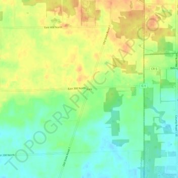
Name: York topographic map, elevation, terrain.

Location: York, Steuben County, Indiana, United States (41.66838 -84.84246 41.70838 -84.80246)

Average elevation: 320 m

Minimum elevation: 300 m

Maximum elevation: 342 m

Other topographic maps

Click on a map to view its topography, its elevation and its terrain.

Orland

United States > Indiana > Steuben County

Average elevation: 291 m

Hamilton

United States > Indiana > Steuben County

Average elevation: 283 m

Clear Lake

United States > Indiana > Steuben County

Average elevation: 321 m

Hudson

United States > Indiana > Steuben County

Average elevation: 300 m

Long Lake

United States > Indiana > Steuben County > Long Lake

Average elevation: 321 m

Gear up for your next adventure:

🧭GPS Tracker - Track your location in remote areas safely
🧴First Aid Kit - Essential first aid supplies for outdoor emergencies
Tent Footprint - Protect tent floor and increase durability
🦟Insect Repellent - Keep mosquitoes and black flies away in wooded areas
🔋Solar Power Bank - Keep your GPS and devices charged during long outdoor trips

As an Amazon Associate, this site earns from qualifying purchases at no extra cost to you.