Geolocate

Bushrod topographic map

Click on the map to display elevation.

About this map

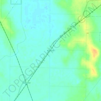
Name: Bushrod topographic map, elevation, terrain.

Location: Bushrod, Greene County, Indiana, 47443, United States (38.94893 -87.12890 38.98893 -87.08890)

Average elevation: 151 m

Minimum elevation: 142 m

Maximum elevation: 172 m

Other topographic maps

Click on a map to view its topography, its elevation and its terrain.

Jasonville

United States > Indiana > Greene County

Average elevation: 185 m

Lyons

United States > Indiana > Greene County

Average elevation: 156 m

Worthington

United States > Indiana > Greene County

Average elevation: 162 m

Switz City

United States > Indiana > Greene County

Average elevation: 162 m

Bloomfield

United States > Indiana > Greene County

Average elevation: 168 m

Linton

United States > Indiana > Greene County

Average elevation: 161 m

Gear up for your next adventure:

🧥Thermal Fleece Jacket - Versatile insulation for changing mountain temperatures
💧Filtered Water Bottle - Safe drinking water on the go
🧴Sunscreen SPF - Broad-spectrum sunscreen for outdoor activities
🧴Insect Repellent - Protect yourself from bugs during outdoor adventures
💧Collapsible Water Bottle - Space-saving water bottle for outdoor activities

As an Amazon Associate, this site earns from qualifying purchases at no extra cost to you.