Geolocate

Woolley topographic map

Click on the map to display elevation.

About this map

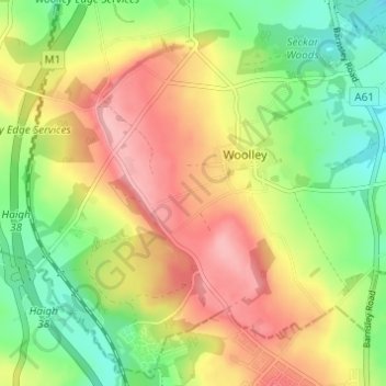
Name: Woolley topographic map, elevation, terrain.

Location: Woolley, Wakefield, West Yorkshire, England, United Kingdom (53.59311 -1.55253 53.62742 -1.49013)

Average elevation: 109 m

Minimum elevation: 49 m

Maximum elevation: 175 m

Gear up for your next adventure:

🦯Trekking Poles - Reduced impact on joints for steep topographic climbs
🥾Mountain Trail Shoes - High-traction shoes for mountain trails
🥾Hiking Shoes - Durable and comfortable shoes for trail hiking
🥤Collapsible Travel Cup - Saves space and weight in your mess kit
🧥Waterproof Pants - Keep dry during rainy hiking conditions

As an Amazon Associate, this site earns from qualifying purchases at no extra cost to you.