
Dixmude topographic map
Interactive map
Click on the map to display elevation.
About this map
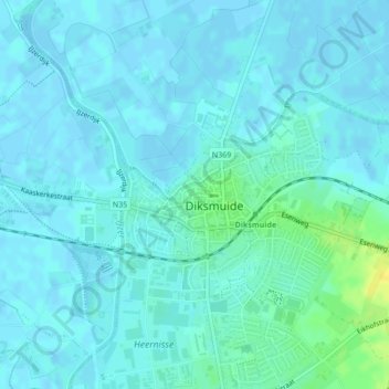
Name: Dixmude topographic map, elevation, terrain.
Location: Dixmude, Flandre-Occidentale, Belgique (51.02678 2.85453 51.04134 2.88311)
Average elevation: 4 m
Minimum elevation: -3 m
Maximum elevation: 21 m
Other topographic maps
Click on a map to view its topography, its elevation and its terrain.
Pervyse
Belgique > Flandre-Occidentale > Dixmude > Dixmude
Pervyse, Dixmude, Flandre-Occidentale, Flandre, Belgique
Average elevation: 1 m