Geolocate

Faribault topographic map

Click on the map to display elevation.

About this map

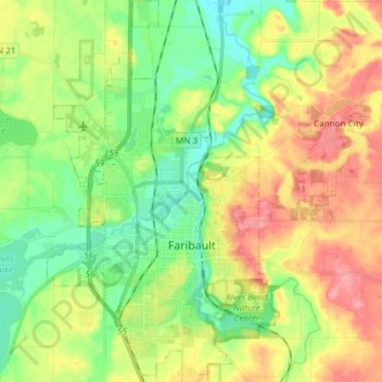
Name: Faribault topographic map, elevation, terrain.

Location: Faribault, Rice County, Minnesota, 55021, United States (44.25637 -93.32552 44.36345 -93.23454)

Average elevation: 325 m

Minimum elevation: 287 m

Maximum elevation: 376 m

Other topographic maps

Click on a map to view its topography, its elevation and its terrain.

Hazelwood

United States > Minnesota > Rice County

Average elevation: 316 m

Walcott

United States > Minnesota > Rice County

Average elevation: 361 m

Warsaw

United States > Minnesota > Rice County

Average elevation: 315 m

Cannon City

United States > Minnesota > Rice County

Average elevation: 348 m

Hidden Falls

United States > Minnesota > Rice County

Average elevation: 353 m

Northfield

United States > Minnesota > Rice County

Average elevation: 300 m

Shieldsville

United States > Minnesota > Rice County

Average elevation: 333 m

Gear up for your next adventure:

Camping Tent - Weather-resistant tents suitable for 2 to 6 people
🥾Hiking Shoes - Durable and comfortable shoes for trail hiking
🥘Camping Cookware Set - Compact nesting pots and pans for trail cooking
🧢Sun Hat - Wide-brim hat for sun protection
🔥Emergency Fire Starter - Reliable ignition source for all weather conditions

As an Amazon Associate, this site earns from qualifying purchases at no extra cost to you.