
Chambly topographic map
Click on the map to display elevation.
About this map
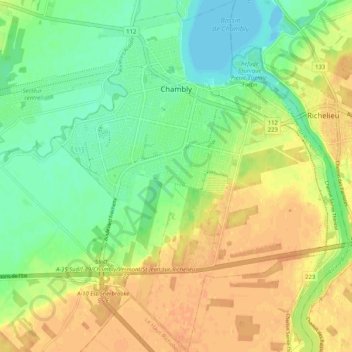
Name: Chambly topographic map, elevation, terrain.
Location: Chambly, La Vallée-du-Richelieu, Montérégie, Quebec, Canada (45.39311 -73.32912 45.46566 -73.24866)
Average elevation: 22 m
Minimum elevation: 5 m
Maximum elevation: 38 m
La Vallée-du-Richelieu trails, hiking, mountain biking, running and outdoor activities
Other topographic maps
Click on a map to view its topography, its elevation and its terrain.
Gault Nature Reserve
Canada > Quebec > La Vallée-du-Richelieu > Mont-Saint-Hilaire
Average elevation: 189 m
La Quenouillère
Canada > Quebec > La Vallée-du-Richelieu > Mont-Saint-Hilaire
Average elevation: 182 m
Mont Saint-Hilaire
Canada > Quebec > La Vallée-du-Richelieu > Mont-Saint-Hilaire
Average elevation: 247 m
Décharge des Quinze du Bas du Quatrième Rang
Canada > Quebec > La Vallée-du-Richelieu > Saint-Charles-sur-Richelieu
Average elevation: 37 m
La Quenouillère
Canada > Quebec > La Vallée-du-Richelieu > Mont-Saint-Hilaire
Average elevation: 182 m
La Quenouillère
Canada > Quebec > La Vallée-du-Richelieu > Mont-Saint-Hilaire
Average elevation: 182 m
La Quenouillère
Canada > Quebec > La Vallée-du-Richelieu > Mont-Saint-Hilaire
Average elevation: 182 m