
Mont Saint-Hilaire topographic map
Interactive map
Click on the map to display elevation.
About this map
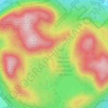
Name: Mont Saint-Hilaire topographic map, elevation, terrain.
Average elevation: 247 m
Minimum elevation: 66 m
Maximum elevation: 396 m
La Vallée-du-Richelieu trails, hiking, mountain biking, running and outdoor activities
Other topographic maps
Click on a map to view its topography, its elevation and its terrain.
Gault Nature Reserve
Canada > Quebec > La Vallée-du-Richelieu > Mont-Saint-Hilaire
Average elevation: 189 m