Geolocate

10th district topographic map

Click on the map to display elevation.

About this map

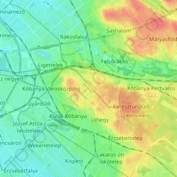
Name: 10th district topographic map, elevation, terrain.

Location: 10th district, Budapest, Central Hungary, Hungary (47.45817 19.09867 47.50673 19.22166)

Average elevation: 129 m

Minimum elevation: 112 m

Maximum elevation: 158 m

Other topographic maps

Click on a map to view its topography, its elevation and its terrain.

Danube

Hungary > Budapest

Average elevation: 114 m

Kis-Sváb-hegy

Hungary > Budapest

Average elevation: 195 m

Gellért Hill

Hungary > Budapest

Average elevation: 126 m

Ziggurat

Hungary > Budapest

Average elevation: 108 m

Csúcs-hegy

Hungary > Budapest

Average elevation: 261 m

Gellért Hill

Hungary > Budapest

Average elevation: 126 m

Tigers

Hungary > Budapest

Average elevation: 111 m

Danube

Hungary > Budapest

Average elevation: 125 m

Gear up for your next adventure:

🔪Outdoor Multitool - Versatile tool for repairs and food prep in the wild
🍽️Titanium Camping Spork - Ultralight and indestructible eating utensil
Family Camping Tent - Spacious tent suitable for family camping trips
👟Leg Gaiters - Keep debris, mud, and snow out of your boots
❄️Traction Ice Cleats - Slip-on spikes for icy trails and winter hiking

As an Amazon Associate, this site earns from qualifying purchases at no extra cost to you.