Geolocate

Bangko topographic map

Click on the map to display elevation.

About this map

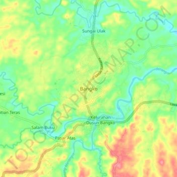
Name: Bangko topographic map, elevation, terrain.

Location: Bangko, Merangin, Jambi, Sumatra, 37313, Indonesia (-2.09996 102.23416 -2.01996 102.31416)

Average elevation: 84 m

Minimum elevation: 49 m

Maximum elevation: 133 m

Other topographic maps

Click on a map to view its topography, its elevation and its terrain.

Air Tembesi

Indonesia > Jambi > Merangin > Koto Teguh

Average elevation: 1,176 m

Batang Tantan

Indonesia > Jambi > Merangin

Average elevation: 150 m

Sungai Keruh

Indonesia > Jambi > Merangin > Rantau Kermas

Average elevation: 1,194 m

Sungai Putih

Indonesia > Jambi > Merangin > Sungai Putih

Average elevation: 122 m

Gear up for your next adventure:

🥾Trail Running Shoes - Lightweight and durable shoes for trail running
🧳Compression Sacks - Maximize space in your backpack by shrinking gear
💧Hydration Pack - Hands-free hydration system for long hikes
🥾Hiking Gaiters - Protect legs and shoes from mud, snow, and debris
Backpacking Tent - Lightweight tent for long-distance hiking trips

As an Amazon Associate, this site earns from qualifying purchases at no extra cost to you.