
Make a donation
Gear up for your next adventure:
As an Amazon Associate, this site earns from qualifying purchases at no extra cost to you.
Comerio topographic map
Click on the map to display elevation.
Make a donation
Gear up for your next adventure:
As an Amazon Associate, this site earns from qualifying purchases at no extra cost to you.
About this map
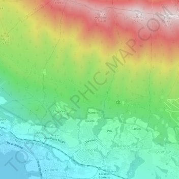
Name: Comerio topographic map, elevation, terrain.
Location: Comerio, Varese, Lombardy, 21025, Italy (45.83345 8.72745 45.87166 8.75639)
Average elevation: 608 m
Minimum elevation: 234 m
Maximum elevation: 1,205 m
Make a donation
Gear up for your next adventure:
As an Amazon Associate, this site earns from qualifying purchases at no extra cost to you.
Other topographic maps
Click on a map to view its topography, its elevation and its terrain.
Parco archeologico di Castel Seprio
Italy > Lombardy > Varese > Castelseprio > Vico Seprio
Average elevation: 314 m
Make a donation
Gear up for your next adventure:
As an Amazon Associate, this site earns from qualifying purchases at no extra cost to you.