
Thank you for supporting this site ❤️
Make a donation
Make a donation
Gear up for your next adventure:
As an Amazon Associate, this site earns from qualifying purchases at no extra cost to you.
Sciuino topographic map
Click on the map to display elevation.
Thank you for supporting this site ❤️
Make a donation
Make a donation
Gear up for your next adventure:
As an Amazon Associate, this site earns from qualifying purchases at no extra cost to you.
About this map
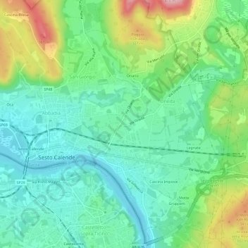
Name: Sciuino topographic map, elevation, terrain.
Location: Sciuino, Oneda, Sesto Calende, Varese, Lombardy, 21018, Italy (45.70928 8.62994 45.74928 8.66994)
Average elevation: 248 m
Minimum elevation: 188 m
Maximum elevation: 384 m
Thank you for supporting this site ❤️
Make a donation
Make a donation
Gear up for your next adventure:
As an Amazon Associate, this site earns from qualifying purchases at no extra cost to you.