Geolocate

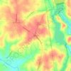
Chester topographic map

Click on the map to display elevation.

About this map

Name: Chester topographic map, elevation, terrain.

Location: Chester, Chester County, South Carolina, United States (34.69079 -81.23529 34.71924 -81.19078)

Average elevation: 161 m

Minimum elevation: 132 m

Maximum elevation: 187 m

Other topographic maps

Click on a map to view its topography, its elevation and its terrain.

Lando

United States > South Carolina > Chester County

Average elevation: 154 m

Edgemoor

United States > South Carolina > Chester County

Average elevation: 165 m

Rodman

United States > South Carolina > Chester County

Average elevation: 170 m

Evans

United States > South Carolina > Chester County

Average elevation: 174 m

Gear up for your next adventure:

🔭Compact Monocular - One-handed bird watching and trail spotting
🌬️Windproof Camp Stove - Efficient cooking even on exposed mountain peaks
🥾Mountain Hiking Shoes - Shoes with superior grip for mountainous terrain
🥾Waterproof Hiking Shoes - Durable shoes for wet and rugged trails
🩹Compact First Aid Kit - Pre-packed essentials for common trail injuries

As an Amazon Associate, this site earns from qualifying purchases at no extra cost to you.