
Make a donation
Gear up for your next adventure:
As an Amazon Associate, this site earns from qualifying purchases at no extra cost to you.
Gemeinde Pöchlarn topographic map
Click on the map to display elevation.
Make a donation
Gear up for your next adventure:
As an Amazon Associate, this site earns from qualifying purchases at no extra cost to you.
About this map
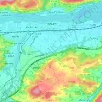
Name: Gemeinde Pöchlarn topographic map, elevation, terrain.
Location: Gemeinde Pöchlarn, Bezirk Melk, Lower Austria, 3380, Austria (48.16989 15.18301 48.22292 15.26970)
Average elevation: 257 m
Minimum elevation: 205 m
Maximum elevation: 391 m
Make a donation
Gear up for your next adventure:
As an Amazon Associate, this site earns from qualifying purchases at no extra cost to you.
Other topographic maps
Click on a map to view its topography, its elevation and its terrain.
Make a donation
Gear up for your next adventure:
As an Amazon Associate, this site earns from qualifying purchases at no extra cost to you.
Persenbeug
Austria > Lower Austria > Bezirk Melk > Gemeinde Persenbeug-Gottsdorf
Average elevation: 261 m