
Thank you for supporting this site ❤️
Make a donation
Make a donation
Gear up for your next adventure:
As an Amazon Associate, this site earns from qualifying purchases at no extra cost to you.
Mank topographic map
Click on the map to display elevation.
Thank you for supporting this site ❤️
Make a donation
Make a donation
Gear up for your next adventure:
As an Amazon Associate, this site earns from qualifying purchases at no extra cost to you.
About this map
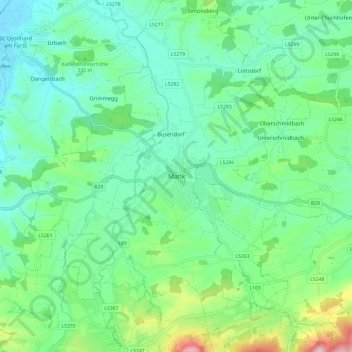
Name: Mank topographic map, elevation, terrain.
Location: Mank, Gemeinde Mank, Bezirk Melk, Lower Austria, 3240, Austria (48.07107 15.30103 48.15107 15.38103)
Average elevation: 315 m
Minimum elevation: 237 m
Maximum elevation: 551 m
Thank you for supporting this site ❤️
Make a donation
Make a donation
Gear up for your next adventure:
As an Amazon Associate, this site earns from qualifying purchases at no extra cost to you.