Geolocate

Bastrop topographic map

Click on the map to display elevation.

About this map

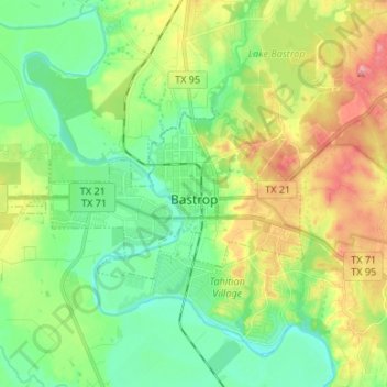
Name: Bastrop topographic map, elevation, terrain.

Location: Bastrop, Bastrop County, Texas, United States (30.08661 -97.41069 30.13769 -97.27760)

Average elevation: 129 m

Minimum elevation: 90 m

Maximum elevation: 200 m

Other topographic maps

Click on a map to view its topography, its elevation and its terrain.

Cedar Creek

United States > Texas > Bastrop County

Average elevation: 125 m

McDade

United States > Texas > Bastrop County

Average elevation: 162 m

Rosanky

United States > Texas > Bastrop County

Average elevation: 153 m

Antioch

United States > Texas > Bastrop County

Average elevation: 149 m

Paige

United States > Texas > Bastrop County

Average elevation: 161 m

High Point

United States > Texas > Bastrop County

Average elevation: 145 m

Rosanky

United States > Texas > Bastrop County

Average elevation: 153 m

Red Rock

United States > Texas > Bastrop County

Average elevation: 152 m

Gear up for your next adventure:

🥾Lightweight Hiking Shoes - Comfortable shoes for day hikes
🥾Waterproof Hiking Boots - Boots keeping your feet dry in wet conditions
🔪Outdoor Multitool - Versatile tool for repairs and food prep in the wild
🥾Trail Hiking Socks - Comfortable socks to prevent blisters and fatigue
🥘Camping Cookware Set - Compact nesting pots and pans for trail cooking

As an Amazon Associate, this site earns from qualifying purchases at no extra cost to you.