
Make a donation
Gear up for your next adventure:
As an Amazon Associate, this site earns from qualifying purchases at no extra cost to you.
Eli topographic map
Click on the map to display elevation.
Make a donation
Gear up for your next adventure:
As an Amazon Associate, this site earns from qualifying purchases at no extra cost to you.
About this map
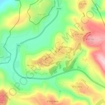
Name: Eli topographic map, elevation, terrain.
Location: Eli, Area C, Judea and Samaria, Palestinian Territories (32.05332 35.25220 32.08931 35.28693)
Average elevation: 638 m
Minimum elevation: 472 m
Maximum elevation: 846 m
Make a donation
Gear up for your next adventure:
As an Amazon Associate, this site earns from qualifying purchases at no extra cost to you.
Other topographic maps
Click on a map to view its topography, its elevation and its terrain.
Mishor Adumim
Palestinian Territories > Judea and Samaria > Area C > Maale Adumim
Average elevation: 265 m
Make a donation
Gear up for your next adventure:
As an Amazon Associate, this site earns from qualifying purchases at no extra cost to you.
Nofim
Palestinian Territories > Judea and Samaria > Area C > Shomron Regional Council
Average elevation: 319 m
Mehora
Palestinian Territories > Judea and Samaria > Area C > Arvot Hayarden Regional Council
Average elevation: 200 m
Fatsael
Palestinian Territories > Judea and Samaria > Area C > Arvot Hayarden Regional Council
Average elevation: -220 m
Make a donation
Gear up for your next adventure:
As an Amazon Associate, this site earns from qualifying purchases at no extra cost to you.
Make a donation
Gear up for your next adventure:
As an Amazon Associate, this site earns from qualifying purchases at no extra cost to you.
Ro'i
Palestinian Territories > Judea and Samaria > Area C > Arvot Hayarden Regional Council
Average elevation: 46 m
Argaman
Palestinian Territories > Judea and Samaria > Area C > Arvot Hayarden Regional Council
Average elevation: -203 m
Make a donation
Gear up for your next adventure:
As an Amazon Associate, this site earns from qualifying purchases at no extra cost to you.
Hamra
Palestinian Territories > Judea and Samaria > Area C > Arvot Hayarden Regional Council
Average elevation: -57 m
Make a donation
Gear up for your next adventure:
As an Amazon Associate, this site earns from qualifying purchases at no extra cost to you.
Homesh
Palestinian Territories > Judea and Samaria > Area C > Shomron Regional Council
Average elevation: 452 m
Beit HaArava
Palestinian Territories > Judea and Samaria > Area C > Megilot Yam HaMelakh Regional Council
Average elevation: -294 m
Make a donation
Gear up for your next adventure:
As an Amazon Associate, this site earns from qualifying purchases at no extra cost to you.