
Make a donation
Gear up for your next adventure:
As an Amazon Associate, this site earns from qualifying purchases at no extra cost to you.
Kfar Etzion topographic map
Click on the map to display elevation.
Make a donation
Gear up for your next adventure:
As an Amazon Associate, this site earns from qualifying purchases at no extra cost to you.
About this map
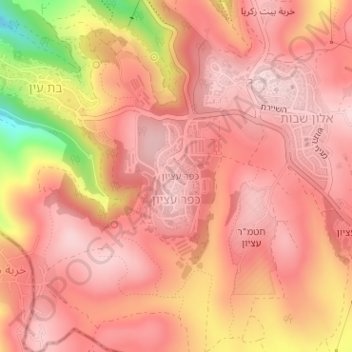
Name: Kfar Etzion topographic map, elevation, terrain.
Average elevation: 904 m
Minimum elevation: 710 m
Maximum elevation: 971 m
Make a donation
Gear up for your next adventure:
As an Amazon Associate, this site earns from qualifying purchases at no extra cost to you.
Other topographic maps
Click on a map to view its topography, its elevation and its terrain.
Qumran National Park
Palestinian Territories > Judea and Samaria > Area C > Megilot Yam HaMelakh Regional Council
Average elevation: -274 m
Make a donation
Gear up for your next adventure:
As an Amazon Associate, this site earns from qualifying purchases at no extra cost to you.
Mehora
Palestinian Territories > Judea and Samaria > Area C > Arvot Hayarden Regional Council
Average elevation: 200 m
Make a donation
Gear up for your next adventure:
As an Amazon Associate, this site earns from qualifying purchases at no extra cost to you.
Megilot Yam HaMelakh Regional Council
Palestinian Territories > Judea and Samaria > Area C
Average elevation: 157 m
Make a donation
Gear up for your next adventure:
As an Amazon Associate, this site earns from qualifying purchases at no extra cost to you.
Homesh
Palestinian Territories > Judea and Samaria > Area C > Shomron Regional Council
Average elevation: 452 m
Az Za'ayyem Bedouins
Palestinian Territories > Judea and Samaria > Area C > 'Anata
Average elevation: 603 m
Make a donation
Gear up for your next adventure:
As an Amazon Associate, this site earns from qualifying purchases at no extra cost to you.