Geolocate

Palo del Colle topographic map

Click on the map to display elevation.

About this map

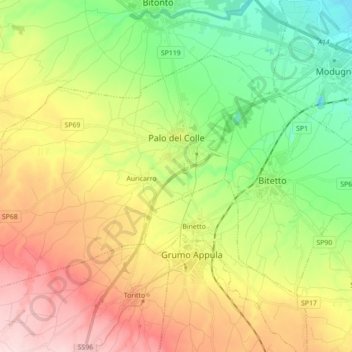
Name: Palo del Colle topographic map, elevation, terrain.

Location: Palo del Colle, Bari, Apulia, 70027, Italy (40.99753 16.56491 41.08860 16.74045)

Average elevation: 170 m

Minimum elevation: 53 m

Maximum elevation: 326 m

Other topographic maps

Click on a map to view its topography, its elevation and its terrain.

Altamura

Italy > Apulia > Bari > Altamura

Average elevation: 409 m

Polignano a Mare

Italy > Apulia > Bari

Average elevation: 42 m

Monte Belvedere

Italy > Apulia > Bari > Altamura

Average elevation: 456 m

Gear up for your next adventure:

🛰️Satellite Messenger - Emergency communication for areas with no cell service
🧭GPS Outdoor Watch - Smart watch for navigation and fitness tracking in nature
🦌Outdoor Trail Camera - Monitor wildlife activity near your favorite spots
🦟Insect Repellent - Keep mosquitoes and black flies away in wooded areas
🐕Hiking Dog Pack - Let your canine companion carry their own water and food

As an Amazon Associate, this site earns from qualifying purchases at no extra cost to you.