
Make a donation
Gear up for your next adventure:
As an Amazon Associate, this site earns from qualifying purchases at no extra cost to you.
Polignano a Mare topographic map
Click on the map to display elevation.
Make a donation
Gear up for your next adventure:
As an Amazon Associate, this site earns from qualifying purchases at no extra cost to you.
About this map
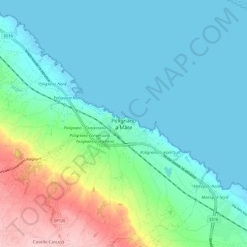
Name: Polignano a Mare topographic map, elevation, terrain.
Location: Polignano a Mare, Bari, Apulia, 70044, Italy (40.95445 17.18249 41.03445 17.26249)
Average elevation: 42 m
Minimum elevation: -4 m
Maximum elevation: 186 m
Make a donation
Gear up for your next adventure:
As an Amazon Associate, this site earns from qualifying purchases at no extra cost to you.
Other topographic maps
Click on a map to view its topography, its elevation and its terrain.
Make a donation
Gear up for your next adventure:
As an Amazon Associate, this site earns from qualifying purchases at no extra cost to you.
Make a donation
Gear up for your next adventure:
As an Amazon Associate, this site earns from qualifying purchases at no extra cost to you.
Santeramo in Colle
By altitude, Santeramo in Colle is the highest municipality in the metropolitan city of Bari.
Average elevation: 418 m
Gioia del Colle
Gioia del Colle is on the top of a hill at 360 m a.s.l. It is located in the southern part of the Murge, in the "Sella di Gioia del Colle". It is between the North-West Murge and the South-West Murge and the Adriatic Sea and the Ionian Sea. The municipal area has an area of 206.48 km2 and it reaches a maximum…
Average elevation: 351 m
Make a donation
Gear up for your next adventure:
As an Amazon Associate, this site earns from qualifying purchases at no extra cost to you.
Make a donation
Gear up for your next adventure:
As an Amazon Associate, this site earns from qualifying purchases at no extra cost to you.
Make a donation
Gear up for your next adventure:
As an Amazon Associate, this site earns from qualifying purchases at no extra cost to you.