Geolocate

Duncanville topographic map

Click on the map to display elevation.

About this map

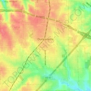
Name: Duncanville topographic map, elevation, terrain.

Location: Duncanville, Dallas County, Texas, United States (32.61871 -96.94331 32.67671 -96.88265)

Average elevation: 213 m

Minimum elevation: 178 m

Maximum elevation: 239 m

Other topographic maps

Click on a map to view its topography, its elevation and its terrain.

Dallas

United States > Texas > Dallas County > Dallas

Dallas and its surrounding area are mostly flat. The city lies at elevations ranging from 450 to 550 feet (137 to 168 m) above sea level. The western edge of the Austin Chalk Formation, a limestone escarpment (also known as the "White Rock Escarpment"), rises 230 feet (70 m) and runs roughly north–south…

Average elevation: 158 m

Garland

United States > Texas > Dallas County > Garland

Average elevation: 164 m

Irving

United States > Texas > Dallas County > Irving

Average elevation: 162 m

Mesquite

United States > Texas > Dallas County > Mesquite

Average elevation: 145 m

Gear up for your next adventure:

🥾Durable Hiking Shoes - Long-lasting shoes for frequent hiking
🥾Trekking Boots - Durable boots for long-distance trekking
🧥Ultralight Puffy Jacket - Maximum warmth that packs down to the size of an orange
🥾Hiking Boots - Sturdy boots providing ankle support and traction on rugged trails
🥤Collapsible Travel Cup - Saves space and weight in your mess kit

As an Amazon Associate, this site earns from qualifying purchases at no extra cost to you.