Geolocate

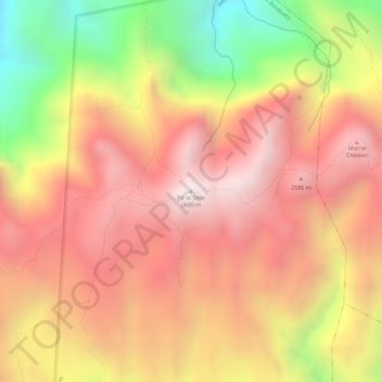
Pic la Selle topographic map

Click on the map to display elevation.

Pic la Selle

A forest of pine trees is present above the elevation of 1,800 metres (5,900 ft). Celestus macrotus is present on the northeastern slopes of Pic la Selle. A report in the 1930s listed white-winged warblers, and eastern chat-tanagers, and Antillean siskins as being present on the mountain. A breeding colony of black-capped petrel was present in the 1960s and the species still inhabitants the mountain as of 2011.

Wikipedia (CC-BY-SA 3.0)

About this map

Name: Pic la Selle topographic map, elevation, terrain.

Location: Pic la Selle, trail from Mare Rouge to Pic la Selle, 7e Belle Fontaine, Commune Croix-des-Bouquets, Arrondissement de Croix-des-Bouquets, West, Haiti (18.36027 -71.97671 18.36037 -71.97661)

Average elevation: 2,364 m

Minimum elevation: 1,832 m

Maximum elevation: 2,675 m

Other topographic maps

Click on a map to view its topography, its elevation and its terrain.
Fault

Haiti > West > Commune Croix-des-Bouquets > Montet

Average elevation: 364 m

Fault

Haiti > West > Commune Croix-des-Bouquets > Montet

Average elevation: 364 m

Gear up for your next adventure:

🥾Waterproof Hiking Boots - Boots keeping your feet dry in wet conditions
🔭Compact Monocular - One-handed bird watching and trail spotting
🚑Survival Whistle - Signal for help across long distances in mountains
🥫Freeze-Dried Meals - Lightweight, high-calorie nutrition for multi-day treks
🥾Waterproof Hiking Shoes - Durable shoes for wet and rugged trails

As an Amazon Associate, this site earns from qualifying purchases at no extra cost to you.