Geolocate

Ludgvan topographic map

Click on the map to display elevation.

About this map

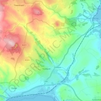
Name: Ludgvan topographic map, elevation, terrain.

Location: Ludgvan, Cornwall, England, United Kingdom (50.12433 -5.53252 50.18973 -5.43768)

Average elevation: 79 m

Minimum elevation: -1 m

Maximum elevation: 231 m

Gear up for your next adventure:

🛶Kayak Accessories - Essential gear for safe and fun kayaking adventures
Bushcraft Tarp - Versatile emergency shelter or gear protection
🥾Mountain Hiking Shoes - Shoes with superior grip for mountainous terrain
Camping Coffee Maker - Brew fresh coffee anywhere on the topographic map
🥾Light Trekking Boots - Supportive boots for multi-day treks

As an Amazon Associate, this site earns from qualifying purchases at no extra cost to you.