Geolocate

Foss topographic map

Click on the map to display elevation.

About this map

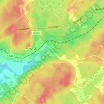
Name: Foss topographic map, elevation, terrain.

Location: Foss, Rydöbruk, Hylte kommun, Halland County, Sweden (56.94060 13.13291 56.98060 13.17291)

Average elevation: 113 m

Minimum elevation: 65 m

Maximum elevation: 158 m

Gear up for your next adventure:

💧Hydration Bladder - Hands-free hydration solution for long treks
🔦LED Headlamp - Hands-free lighting for early morning starts or late finishes
🔪Outdoor Multitool - Versatile tool for repairs and food prep in the wild
🥾All-Terrain Hiking Boots - Versatile boots for varied hiking conditions
🥾Approach Shoes - Shoes designed for climbing approaches and rugged trails

As an Amazon Associate, this site earns from qualifying purchases at no extra cost to you.