Geolocate

Pauri topographic map

Click on the map to display elevation.

About this map

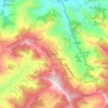
Name: Pauri topographic map, elevation, terrain.

Location: Pauri, Pauri Garhwal, Uttarakhand, 246001, India (30.10799 78.73595 30.18799 78.81595)

Average elevation: 1,423 m

Minimum elevation: 755 m

Maximum elevation: 2,122 m

Gear up for your next adventure:

🎒Fully Waterproof Backpack - Total protection for photography gear and electronics
🐕Hiking Dog Pack - Let your canine companion carry their own water and food
🔦UV Flashlight - Detect minerals or specific insects in the dark
🧢Sun Protection Cap - Breathable cap to protect from sun exposure
👖Convertible Hiking Pants - Zip-off legs to adapt to changing weather conditions

As an Amazon Associate, this site earns from qualifying purchases at no extra cost to you.