
Make a donation
Gear up for your next adventure:
As an Amazon Associate, this site earns from qualifying purchases at no extra cost to you.
Vega de Valcarce topographic map
Click on the map to display elevation.
Make a donation
Gear up for your next adventure:
As an Amazon Associate, this site earns from qualifying purchases at no extra cost to you.
About this map
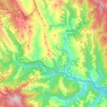
Name: Vega de Valcarce topographic map, elevation, terrain.
Location: Vega de Valcarce, El Bierzo, León, Kastilien und León, Spanien (42.63790 -7.04474 42.72938 -6.89976)
Average elevation: 947 m
Minimum elevation: 553 m
Maximum elevation: 1,590 m
Make a donation
Gear up for your next adventure:
As an Amazon Associate, this site earns from qualifying purchases at no extra cost to you.
Other topographic maps
Click on a map to view its topography, its elevation and its terrain.
Camino Paradela - Castillo de Cornatel (Camino de los Castaños)
Spanien > Kastilien und León > El Bierzo > Priaranza del Bierzo > Paradela de Muces
Average elevation: 785 m
Tedejo
Spanien > Kastilien und León > El Bierzo > Folgoso de la Ribera > Tedejo
Average elevation: 859 m
Anllares del Sil
Spanien > Kastilien und León > El Bierzo > Páramo del Sil > Anllares del Sil
Average elevation: 1,062 m
Ponferrada
Spanien > Kastilien und León > El Bierzo > Ponferrada > Ponferrada
Die Stadt Ponferrada liegt am Zusammenfluss von Sil und Boeza in der hügeligen bis gebirgigen Landschaft des Bierzo knapp 115 km (Fahrtstrecke) westlich der Provinzhauptstadt León auf etwa 510 m Höhe. Das Klima ist gemäßigt bis warm; Regen (ca. 650 mm/Jahr) fällt überwiegend im Winterhalbjahr.
Average elevation: 584 m
Make a donation
Gear up for your next adventure:
As an Amazon Associate, this site earns from qualifying purchases at no extra cost to you.