
Make a donation
Gear up for your next adventure:
As an Amazon Associate, this site earns from qualifying purchases at no extra cost to you.
Ponferrada topographic map
Click on the map to display elevation.
Make a donation
Gear up for your next adventure:
As an Amazon Associate, this site earns from qualifying purchases at no extra cost to you.
Ponferrada
Die Stadt Ponferrada liegt am Zusammenfluss von Sil und Boeza in der hügeligen bis gebirgigen Landschaft des Bierzo knapp 115 km (Fahrtstrecke) westlich der Provinzhauptstadt León auf etwa 510 m Höhe. Das Klima ist gemäßigt bis warm; Regen (ca. 650 mm/Jahr) fällt überwiegend im Winterhalbjahr.
Make a donation
Gear up for your next adventure:
As an Amazon Associate, this site earns from qualifying purchases at no extra cost to you.
About this map
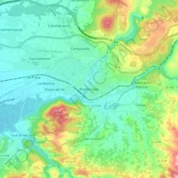
Name: Ponferrada topographic map, elevation, terrain.
Average elevation: 584 m
Minimum elevation: 476 m
Maximum elevation: 857 m
Make a donation
Gear up for your next adventure:
As an Amazon Associate, this site earns from qualifying purchases at no extra cost to you.