Geolocate

Grassington topographic map

Click on the map to display elevation.

About this map
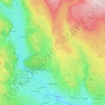
Name: Grassington topographic map, elevation, terrain.

Location: Grassington, North Yorkshire, York and North Yorkshire, England, United Kingdom (54.05957 -2.03103 54.12641 -1.92510)

Average elevation: 310 m

Minimum elevation: 153 m

Maximum elevation: 555 m

Other topographic maps

Click on a map to view its topography, its elevation and its terrain.
Harrogate

United Kingdom > England > North Yorkshire

Harrogate is situated on the edge of the Yorkshire Dales, with the Vale of York to the east and the upland Yorkshire Dales to the west and north-west. It has a dry and mild climate, typical of places in the rain shadow of the Pennines. It is on the A59 from Skipton to York. At an altitude of between 100 and…

Average elevation: 106 m
Reeth

United Kingdom > England > North Yorkshire > Reeth

Average elevation: 295 m

Osgodby

United Kingdom > England > North Yorkshire

Average elevation: 43 m

Dalton Moor

United Kingdom > England > North Yorkshire > Dalton

Average elevation: 27 m

Water Houses

United Kingdom > England > North Yorkshire

Average elevation: 431 m

Hill

United Kingdom > England > North Yorkshire > Coniston Cold

Average elevation: 158 m

Gear up for your next adventure:

🦟Insect Repellent - Keep mosquitoes and black flies away in wooded areas
👟Leg Gaiters - Keep debris, mud, and snow out of your boots
🧴Sunscreen SPF - Broad-spectrum sunscreen for outdoor activities
🧴Outdoor Sunscreen - High SPF protection for high-altitude UV exposure
🔋Lithium AA Batteries - Long-lasting power that performs in extreme cold

As an Amazon Associate, this site earns from qualifying purchases at no extra cost to you.