
Raunds topographic map
Click on the map to display elevation.
About this map
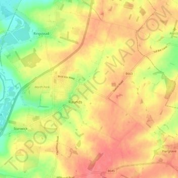
Name: Raunds topographic map, elevation, terrain.
Location: Raunds, North Northamptonshire, England, United Kingdom (52.32156 -0.57858 52.37160 -0.47735)
Average elevation: 65 m
Minimum elevation: 28 m
Maximum elevation: 91 m
Other topographic maps
Click on a map to view its topography, its elevation and its terrain.
Irchester Country Park
United Kingdom > England > North Northamptonshire > Little Irchester
Average elevation: 60 m
River Nene Navigation
United Kingdom > England > North Northamptonshire > Irchester
Average elevation: 55 m