Geolocate

Mom topographic map

Click on the map to display elevation.

About this map

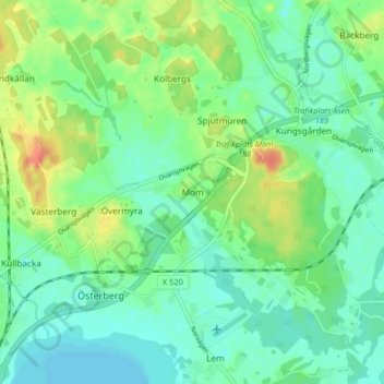
Name: Mom topographic map, elevation, terrain.

Location: Mom, Sandvikens kommun, Gävleborg County, 812 40, Sweden (60.58089 16.56013 60.62089 16.60013)

Average elevation: 71 m

Minimum elevation: 57 m

Maximum elevation: 99 m

Other topographic maps

Click on a map to view its topography, its elevation and its terrain.

Gran

Sweden > Gävleborg County > Gnarp District

Average elevation: 0 m

Ljusdals kommun

Sweden > Gävleborg County

Average elevation: 315 m

Disan

Sweden > Gävleborg County

Average elevation: 43 m

Hamra

Sweden > Gävleborg County

Average elevation: 437 m

Hamra

Sweden > Gävleborg County

Average elevation: 437 m

Hamra

Sweden > Gävleborg County

Average elevation: 437 m

Söderhamns kommun

Sweden > Gävleborg County

Average elevation: 67 m

Gnarp District

Sweden > Gävleborg County

Average elevation: 32 m

Hudiksvalls kommun

Sweden > Gävleborg County

Average elevation: 95 m

Gävle kommun

Sweden > Gävleborg County

Average elevation: 61 m

Gävle

Sweden > Gävleborg County

Average elevation: 28 m

Ovanåkers kommun

Sweden > Gävleborg County

Average elevation: 269 m

Hofors kommun

Sweden > Gävleborg County

Average elevation: 147 m

Gear up for your next adventure:

🧥Packable Rain Jacket - Breathable waterproof layer for unpredictable weather
🎒Hiking Daypack - Lightweight and durable backpacks for day trips and excursions
Lightweight Backpacking Tent - Compact tent for efficient hiking trips
🛏️Sleeping Bag - Warm and compact sleeping bags for outdoor camping
🥾Approach Shoes - Shoes designed for climbing approaches and rugged trails

As an Amazon Associate, this site earns from qualifying purchases at no extra cost to you.