
Make a donation
Gear up for your next adventure:
As an Amazon Associate, this site earns from qualifying purchases at no extra cost to you.
Askham Bog Nature Reserve topographic map
Click on the map to display elevation.
Make a donation
Gear up for your next adventure:
As an Amazon Associate, this site earns from qualifying purchases at no extra cost to you.
Askham Bog Nature Reserve
However, subsequent colonization by common reed, whose fossilized root fragments have been found immediately above the nekron mud layer, lead to a reduced extent of open water. In turn, a layer of fen peat gradually accumulated above the mud in the bog centre to begin forming a raised bog. The increased elevation of the central peat mound began to cut off the direct influx of base-rich waters into the bog from the surrounding land and existing bases in the raised peat were leached out through rainfall. Therefore, net loss of bases from the peat in the centre of the bog gradually led to increased soil acidity, with loss of the original rich fen community which previously covered the whole area.
Make a donation
Gear up for your next adventure:
As an Amazon Associate, this site earns from qualifying purchases at no extra cost to you.
About this map
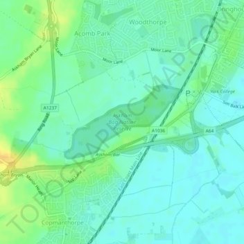
Name: Askham Bog Nature Reserve topographic map, elevation, terrain.
Average elevation: 16 m
Minimum elevation: 7 m
Maximum elevation: 33 m
Make a donation
Gear up for your next adventure:
As an Amazon Associate, this site earns from qualifying purchases at no extra cost to you.