
Make a donation
Gear up for your next adventure:
As an Amazon Associate, this site earns from qualifying purchases at no extra cost to you.
Syke topographic map
Click on the map to display elevation.
Make a donation
Gear up for your next adventure:
As an Amazon Associate, this site earns from qualifying purchases at no extra cost to you.
Syke
Syke liegt in einer Moränenlandschaft mit bewaldeten Höhen und eiszeitlichen Talmulden. Nordwestlich des Ortes liegt der Hohe Berg. Die Stadt lag an einem Heerweg zwischen Verden und Wildeshausen. Inseln im breiten Hachetal ermöglichten hier einen Übergang. Es wurde ein Bohlenweg gebaut. Dort, wo heute die „Hauptstraße“ in Syke verläuft, wurde ein Damm aufgeschüttet.
Make a donation
Gear up for your next adventure:
As an Amazon Associate, this site earns from qualifying purchases at no extra cost to you.
About this map
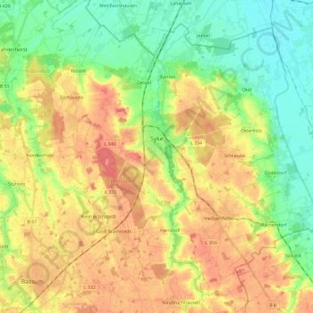
Name: Syke topographic map, elevation, terrain.
Location: Syke, Landkreis Diepholz, Niedersachsen, 28857, Deutschland (52.83537 8.73140 52.97431 8.95208)
Average elevation: 33 m
Minimum elevation: 5 m
Maximum elevation: 64 m
Make a donation
Gear up for your next adventure:
As an Amazon Associate, this site earns from qualifying purchases at no extra cost to you.
Other topographic maps
Click on a map to view its topography, its elevation and its terrain.
Hohnholz
Deutschland > Niedersachsen > Landkreis Diepholz > Twistringen > Abbenhausen
Average elevation: 48 m
Make a donation
Gear up for your next adventure:
As an Amazon Associate, this site earns from qualifying purchases at no extra cost to you.
Make a donation
Gear up for your next adventure:
As an Amazon Associate, this site earns from qualifying purchases at no extra cost to you.
Fesenfeld
Deutschland > Niedersachsen > Landkreis Diepholz > Bassum > Nordwohlde
Average elevation: 33 m
Make a donation
Gear up for your next adventure:
As an Amazon Associate, this site earns from qualifying purchases at no extra cost to you.
Otersen
Deutschland > Niedersachsen > Landkreis Diepholz > Bruchhausen-Vilsen > Süstedt
Average elevation: 50 m
Üssinghausen
Deutschland > Niedersachsen > Landkreis Diepholz > Twistringen > Abbenhausen
Average elevation: 50 m
Make a donation
Gear up for your next adventure:
As an Amazon Associate, this site earns from qualifying purchases at no extra cost to you.
Make a donation
Gear up for your next adventure:
As an Amazon Associate, this site earns from qualifying purchases at no extra cost to you.
Make a donation
Gear up for your next adventure:
As an Amazon Associate, this site earns from qualifying purchases at no extra cost to you.
Tuschendorf
Deutschland > Niedersachsen > Landkreis Diepholz > Martfeld > Tuschendorf
Average elevation: 14 m
Make a donation
Gear up for your next adventure:
As an Amazon Associate, this site earns from qualifying purchases at no extra cost to you.
Scholen
Deutschland > Niedersachsen > Landkreis Diepholz > Bruchhausen-Vilsen > Scholen
Average elevation: 56 m
Ellinghausen
Deutschland > Niedersachsen > Landkreis Diepholz > Twistringen > Heiligenloh
Average elevation: 50 m
Make a donation
Gear up for your next adventure:
As an Amazon Associate, this site earns from qualifying purchases at no extra cost to you.