Geolocate

Letojanni topographic map

Click on the map to display elevation.

About this map

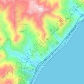
Name: Letojanni topographic map, elevation, terrain.

Location: Letojanni, Messina, Sicily, 98037, Italy (37.87549 15.27987 37.90967 15.33593)

Average elevation: 218 m

Minimum elevation: -1 m

Maximum elevation: 667 m

Other topographic maps

Click on a map to view its topography, its elevation and its terrain.

Castel di Tusa

Italy > Sicily > Messina

Average elevation: 96 m

Monte Serro

Italy > Sicily > Messina > Messina

Average elevation: 92 m

Sperone

Italy > Sicily > Messina > Messina

Average elevation: 56 m

Messina

Italy > Sicily > Messina > Messina

Average elevation: 180 m

Gear up for your next adventure:

🦟Insect Repellent - Keep mosquitoes and black flies away in wooded areas
🏕️Camping Hammock - Integrated protection for sleeping between trees
🔋Emergency Crank Radio - Weather alerts and power without needing batteries
🦶Anti-Blister Balm - Prevents friction and hotspots during long ascents
💧Hydration Bladder - Hands-free hydration solution for long treks

As an Amazon Associate, this site earns from qualifying purchases at no extra cost to you.