
Make a donation
Gear up for your next adventure:
As an Amazon Associate, this site earns from qualifying purchases at no extra cost to you.
Col de la République topographic map
Click on the map to display elevation.
Make a donation
Gear up for your next adventure:
As an Amazon Associate, this site earns from qualifying purchases at no extra cost to you.
Col de la République
Le col de la République ou col du Grand Bois est situé sur la RD 1082 (ex-RN 82) et relie Saint-Étienne au nord de l'Ardèche. La route qui le franchit, dans les monts du Pilat, culmine à une altitude de 1 161 m. Il se situe sur la commune de Saint-Genest-Malifaux.
Make a donation
Gear up for your next adventure:
As an Amazon Associate, this site earns from qualifying purchases at no extra cost to you.
About this map
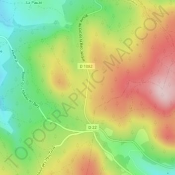
Name: Col de la République topographic map, elevation, terrain.
Average elevation: 1,142 m
Minimum elevation: 1,004 m
Maximum elevation: 1,294 m
Make a donation
Gear up for your next adventure:
As an Amazon Associate, this site earns from qualifying purchases at no extra cost to you.