
Province of San Antonio de Putina topographic map
Interactive map
Click on the map to display elevation.
About this map
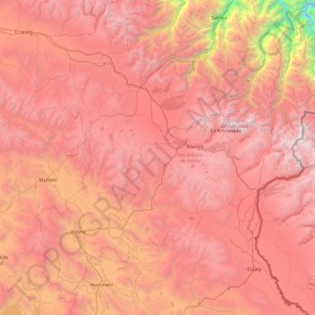
Name: Province of San Antonio de Putina topographic map, elevation, terrain.
Location: Province of San Antonio de Putina, Puno, Peru (-15.11080 -70.01183 -14.30696 -69.11265)
Average elevation: 4,299 m
Minimum elevation: 1,571 m
Maximum elevation: 5,966 m
Other topographic maps
Click on a map to view its topography, its elevation and its terrain.
Lecce Pata
Lecce Pata, Corani, Province of Carabaya, Puno, Peru
Average elevation: 4,436 m
San Fracisco
San Fracisco, Putina, Province of San Antonio de Putina, Puno, Peru
Average elevation: 3,902 m
Province of San Antonio de Putina
Province of San Antonio de Putina, Puno, Peru
Average elevation: 3,612 m