Geolocate

Cona topographic map

Click on the map to display elevation.

About this map

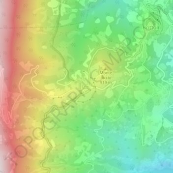
Name: Cona topographic map, elevation, terrain.

Location: Cona, Brittoli, Pescara, Abruzzo, Italy (42.30695 13.84542 42.30920 13.85213)

Average elevation: 818 m

Minimum elevation: 453 m

Maximum elevation: 1,317 m

Other topographic maps

Click on a map to view its topography, its elevation and its terrain.

11

Italy > Abruzzo > Pescara > Brittoli > Boragne

Average elevation: 603 m

Gear up for your next adventure:

🏃Hydration Running Vest - Carry water and maps close to your body for speed
🧶550 Survival Paracord - Versatile utility cord for emergency repairs and rigging
🥾Trekking Boots - Durable boots for long-distance trekking
💧Collapsible Water Bottle - Space-saving water bottle for outdoor activities
🧴Insect Repellent - Protect yourself from bugs during outdoor adventures

As an Amazon Associate, this site earns from qualifying purchases at no extra cost to you.